

Introduction
In the heart of Canada, the Rideau Canal, a unique monument to nineteenth-century engineering, stretches between the modern capital of Ottawa and the historic city of Kingston. This majestic 202-kilometer-long waterway connecting the Ottawa River to Lake Ontario is not only a technical achievement of its time, but also an important historical, cultural and economic artery of Canada. Built between 1826 and 1832 under the direction of Lt. Col. John Bye of the British Royal Engineers, the Rideau Canal is the oldest operating canal system in North America, retaining most of its original structures. In 2007, UNESCO recognized this unique waterway as a World Heritage Site, noting it as “an outstanding example of European retaining water canal technology in North America.”
In this article, we will examine the history of the Rideau Canal, its technical characteristics, its historical significance to Canada, and its current use as an important tourist and recreational attraction.
Historical background to the construction
The War of 1812 and military necessity
The history of the Rideau Canal is inextricably linked to the Anglo-American War of 1812-1815. This war between the United States and Great Britain (including Canada as a British colony) left a deep imprint on the minds of Canadians and British military strategists. Although the fighting ended without territorial changes, the war revealed serious vulnerabilities in the lines of communication between Montreal and the naval base at Kingston on Lake Ontario.
During the war, British garrisons in Upper Canada (present-day southern Ontario) were supplied by the St. Lawrence River. However, the southern bank of this river belonged to the United States, making the supply route vulnerable to possible blockade or attack in the event of a new military conflict. The Americans had already made several attempts to attack Kingston during the War of 1812 from their naval base at Sackets Harbor.
After the war ended, British military leaders began looking for an alternative safe route to move troops and supplies between Montreal and Kingston. Attention turned to a route that would run inland along the Ottawa and Rideau Rivers, Rideau Lakes and the Cataraqui River. Such a route would be protected from possible American attack.
First studies and planning
The first studies of the so-called Rideau Route were made as early as 1783, but serious planning did not begin until after the War of 1812. In 1816, Lt. Joshua Jebb of the Royal Engineers mapped this route from a military perspective. However, due to the depletion of British coffers after the long Napoleonic Wars, funding for such a large-scale canal project in Canada was delayed.
Arthur Wellesley, better known as the Duke of Wellington (or “Iron Duke”), played a key role in promoting the Rideau Canal project. The famed military commander, who had defeated Napoleon at Waterloo, was appointed in 1819 to the post of General Chief of Artillery. This department was responsible for fortifications, supply routes and engineering works. Wellington lobbied heavily for the construction of the Rideau Canal as an important defensive facility to protect British interests in North America.
In the early 1820s, the Lieutenant Governor of Upper Canada established the Macaulay Commission to study inland shipping routes. In 1823-1824, surveyor Samuel Close made a detailed survey and cost estimate for the construction of the Rideau Canal. However, the Upper Canada legislature was more concerned with commercial trade and did not see significant commercial potential in the Rideau Canal.
A British military commission set up to study the details of the Rideau route reported in 1825 that there was no chance of Upper Canada participating in the Rideau project. Nevertheless, the military importance of the Rideau Canal to Canada’s defense remained unchanged, and the decision was made to build it at the expense of the British treasury.
The construction of the Rideau Canal: an ambitious engineering project
Lt. Col. John Bye and the beginning of construction
In 1826, Lieutenant Colonel John Bye of the Royal Engineers was appointed project manager for the construction of the Rideau Canal. Bye was born on August 7, 1779, in Lambeth, England, and was educated at the Royal Military Academy at Woolwich. Prior to his appointment to the Rideau Canal Project, he served in Canada from 1802 to 1811, where he worked to fortify Quebec and improve the navigability of the St. Lawrence River. He also participated in the Napoleonic Wars in Portugal and supervised the reconstruction of the Royal Gunpowder Works at Waltham Abbey after the 1811 explosion.
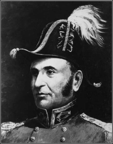
Lieutenant Colonel John Bye, supervisor of the construction of the Rideau Canal. Source: Wikipedia
Upon arriving in Canada to supervise the construction of the canal, Bye was faced with the need to establish a settlement to house workers and related services. This settlement, originally named Baytown in his honor, was later renamed Ottawa and became the capital of Canada.
Construction of the canal began in the fall of 1826 with the preparation of the area for the locks at Ottawa. Major work on the rest of the route began in 1827. Lt. Col. Bye made the strategic decision to build the canal using slackwater technology, which avoided building new canals to bypass the rapids. Instead, dams were used to raise the water level and flood the rapids.
Labor and technical difficulties
Construction was entrusted to private contractors such as future sugar entrepreneur John Redpath, Thomas Mackay, Robert Drummond, Thomas Phillips, Andrew White, and others. However, the bulk of the work was done by thousands of Irish, Scottish and French-Canadian laborers.
Labor conditions were extremely harsh. Workers labored in the wilderness, far from settlements, often in swampy and rugged terrain. They had to manually fell trees, cut rocks, dig earth, and lay rocks to build locks and dams. Work continued almost year-round, including the harsh Canadian winters. The work of building dams and locks in rough rapids and rocky terrain was especially difficult.
The technologies available at the time were used for construction: hand tools for excavation, horses and oxen for transportation of materials, primitive hoists and explosives for crushing rock. Despite being technologically backward by modern standards, engineers and laborers were able to create sophisticated hydraulic structures, most of which are still in service today.
Due to diseases, especially malaria, and harsh working conditions, about a thousand workers died during the construction of the canal. Malaria was endemic to Ontario within the range of the Anopheles mosquito. Accidents were relatively rare for a project of this magnitude; seven accidental deaths were recorded in 1827.
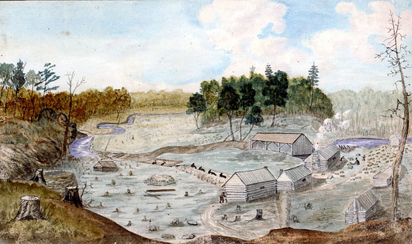
Historical image of the construction of the Rideau Canal. Source: Rideau-Info
Completion of the project and the first voyage
The canal was completed in the spring of 1832, a remarkable engineering achievement for its time. The first full steam voyage on the canal was made by Robert Drummond’s steamer Rideau (also known as the Pomper), which departed Kingston on May 22, 1832, with Colonel Baye and his family aboard, and arrived in Baytown on May 29, 1832.
The total cost of building the canal was £822,804, with all costs including land acquisition (as of January 1834). This far exceeded the original budget of £169,000, resulting in a political scandal for the Artillery Board in London.
Specifications of the Rideau Canal
Route and dimensions
The Rideau Canal is a 202 kilometer long waterway connecting the Ottawa River in the City of Ottawa to the Cataraqui River and Lake Ontario in Kingston. The canal route follows natural bodies of water: the Rideau and Cataraqui Rivers, as well as several lakes, including Lower, Upper and Great Rideau Lake. Only about 19 kilometers are artificially dredged canals.
The Rideau Canal lock system lifts vessels 83 meters (272 feet) upstream along the Rideau River to Rideau Lakes, and then lowers them 50 meters (164 feet) downstream along the Cataraqui River to Kingston. This provides smooth navigation all along the route, overcoming natural obstacles in the form of rapids, waterfalls and gradients.
Lock and Dam
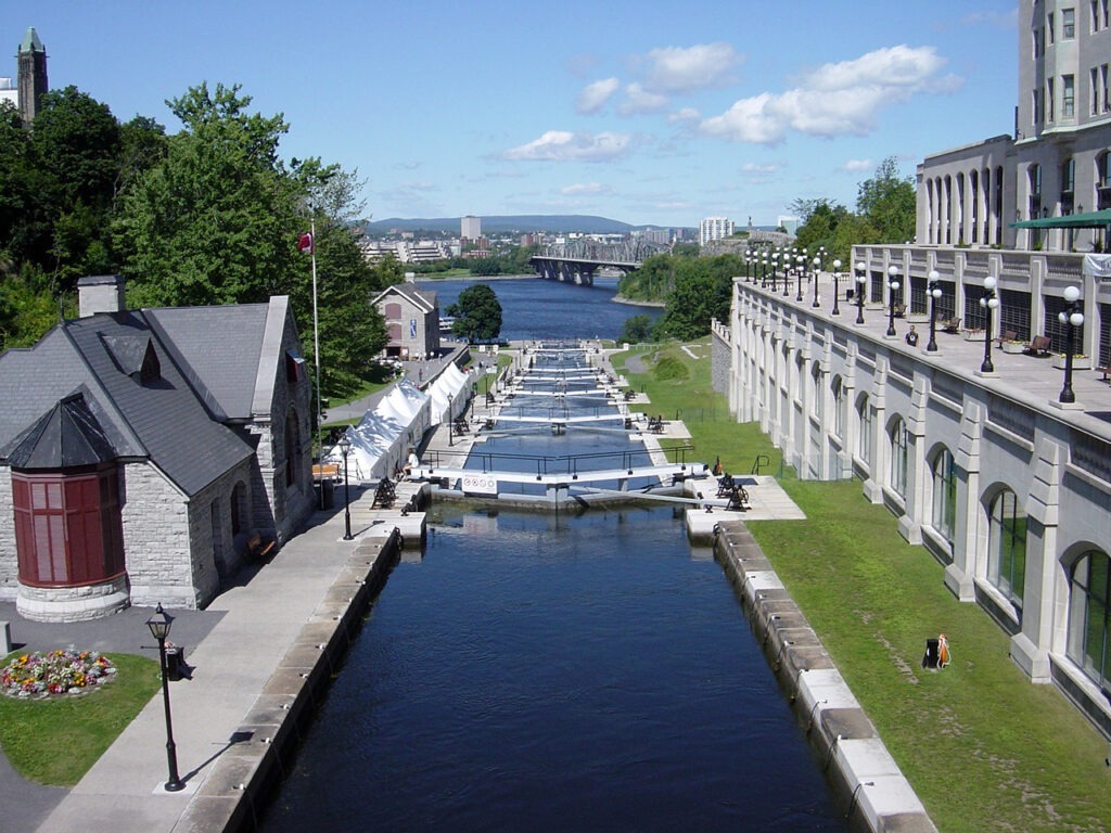
The Rideau Canal comprises 47 locks at 24 lock stations along the waterway, as well as 2 locks (number 33 and 34) at the entrance to the Tay Canal leading to Perth. Most of the locks are still manually operated, which is a unique feature of the canal and attracts tourists.
The locks have the following parameters:
- Maximum length of vessels: 27.43 meters (90 feet)
- Maximum vessel width: 7.92 meters (26 feet)
- Maximum draft of vessels: 1.5 meters (5 feet), although only a draft of 4 feet is guaranteed
John Bye originally requested that the 150-foot-long locks be built specifically for the military purpose of accommodating the new steam gunboats. In June 1828, he got part of what he wanted: it was decided to increase the length of the locks from 108 to 134 feet, although they were later built somewhat smaller.
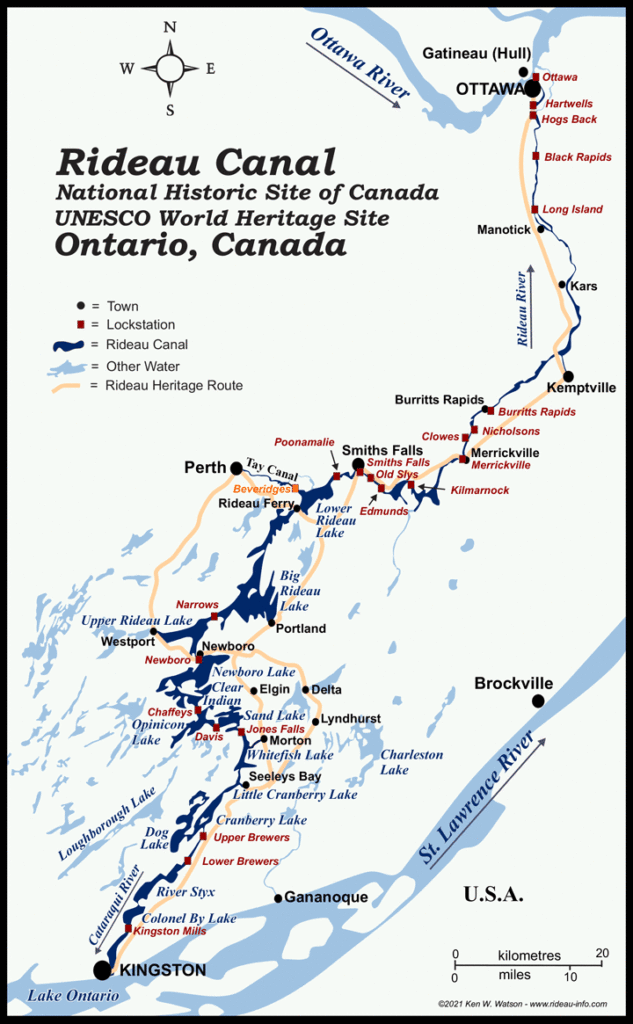
Map of the Rideau Canal showing the locks. Source: Rideau-Info
Defensive Structures
With the completion of the locks and dams in early 1832, Colonel Bye embarked on the next military requirement for the Rideau Canal: defensive works. With the long-term goal of creating blockhouses at all lock stations, he initiated the construction of five of them. Four and a half were completed before orders came to stop construction due to cost overruns that caused discontent in the British Parliament.
The four completed blockhouses are at Kingston Mills, Newborough, Narrows and Merrickville. the “half-completed” blockhouse was at Burritts Rapids, where only the stone first floor was completed before construction stopped.
The Upper Canada Rebellion of 1837-38 caused renewed concern about the vulnerability of lock stations. In 1838, orders came to build wooden guardhouses at two critical points, Jones Falls and at Whitefish [Morton] Dam. In time, stronger stone guard houses for lock keepers were erected at most of the lock stations.
There were also plans to build forts to protect the canal, including a fort on the hill where the Canadian Parliament now stands (then known as Barrack Hill, renamed Citadel Hill on the 1838 map) and a fort at Kingston Mills. However, these plans were not realized.
Historical role and significance of the canal
The military role of the Rideau Canal
While it is often claimed that the Rideau Canal never served its original military purpose, this is not entirely true. The canal did serve a military function, although the large-scale conflict for which it was built did not occur.
The most notable example of the canal’s military use is the movement of the Royal Marines from Ottawa to Kingston in June 1838. They took part in the “Battle of the Windmill” against the American Patriot Hunters who had invaded Canada in November 1838. In this battle, one Marine was killed and several were wounded. It is documented that other troops and supplies used in the battle were also transported through the Rideau Canal.
The canal continued to play a role in military planning during the Oregon Crisis of 1844, when tensions between the U.S. and Britain rose again. Canadian military leaders again noted the wisdom of building the Rideau Canal, which provided a safe route for military supplies to Kingston. Military plans for Upper Canada called for the St. Lawrence River as the first line of defense, with sections of the Rideau Canal as the second line. Command of the Rideau Canal defenses was planned to be established at the Merrickville Blockhouse.
By 1856, relations with the United States had improved and much of the military apprehension had disappeared. The Rideau Canal was transferred from military to civil administration with ownership transferred from Britain to Upper Canada.
The last time the canal and its fortifications were factored into military planning was during the American Civil War, when relations between the U.S. and Canada deteriorated again, reaching a peak in 1862 when the Union captured the British ship Trent, carrying Confederate envoys to Europe. In Merrickville, lock keeper John Johnson began preparations to vacate the Merrickville Blockhouse, thinking the military would need it.
Economic role and commercial use
From its inception in 1832, the Rideau Canal was used for commercial shipping. Despite its original military purpose, the canal quickly became an important trade route for the transportation of goods between Ottawa and Kingston.
In its first decades of operation, the canal promoted trade and industry in the region. It transported timber, grain, minerals, and other goods. The canal also facilitated the settlement of previously inaccessible areas along its route.
However, with the construction of more developed railroads to rural Ontario after World War I and the establishment of the St. Lawrence Seaway, commercial freight gradually shifted to these alternative routes. The Rideau Canal continued to serve Canada as a commercial route, but its economic importance was declining.
Beginning in the late 19th century, the canal began to transform into a recreational waterway, which is its primary function today.
Cultural heritage and UNESCO recognition
In 1925, the Rideau Canal was declared a National Historic Site of Canada, reflecting its historical importance to the country. In 2000, the Rideau Waterway was designated a Canadian Heritage River in recognition of its outstanding historical and recreational value.
A major recognition of the Rideau Canal’s significance was its inclusion on the UNESCO World Heritage List on June 27, 2007. UNESCO recognized the Rideau Canal as a work of human creative genius and as the best surviving example of a canal with retaining water technology in North America, demonstrating the use of European retaining water technology in North America on a large scale. It is the only canal dating from the great era of canal construction in North America in the early nineteenth century that continues to function on its original route with most of the original structures.
The canal has also been recognized as an extensive, well-preserved and significant example of a canal that was used for military purposes related to a significant phase of human history – the struggle for control of the north of the American continent.
The Rideau Canal is a UNESCO World Heritage Site. Source: UNESCO
The Rideau Canal today
Current use and tourist significance
Today, the Rideau Canal is an important tourist attraction and recreational facility. It is visited by thousands of tourists each year, attracted by its historical significance, scenic views and water recreation opportunities.
From May through October, the canal is used by water recreation enthusiasts and private boat owners. Traveling by motorboat through the entire Rideau Canal system takes about 35 days one way. Boat tours of the canal are offered in Ottawa, Kingston, Merrickville and Chaffey’s Lock. The cruise line operates a vessel, the Kawartha Voyageur, which travels between Ottawa and Kingston.
During the summer months, various festivals and events take place along the canal, attracting locals and tourists alike. Popular outdoor activities include kayaking, canoeing, fishing and picnics along the canal.
Winter Coil Rink
Since the winter of 1970-71, the section of the Rideau Canal that runs through downtown Ottawa has been converted into what is officially the world’s largest and second longest ice skating rink. The cleared length is 7.8 kilometers and the surface area is equivalent to 90 Olympic hockey fields. The rink extends from the Hartwells Lock Station at Carleton University to the locks between the Houses of Parliament and Chateau-Laurier, including Lake Dow in between.
The rink is a popular tourist attraction and recreation area, and is the centerpiece of Ottawa’s Winterlude festival. An average of one million people visit the rink each year. City Councillor and author Clive Doucet believes this canal transformation has revitalized the communities of Glib, Old East Ottawa and Old South Ottawa.

The famous ice skating rink on the Rideau Canal in winter. Source: Go World Travel Magazine
Ecological and Natural Significance
The waterway is home to many species of birds, reptiles, amphibians, mammals and fish. The canal and its surroundings represent an important ecosystem that supports the region’s biodiversity.
The ecological value of the canal is recognized both locally and nationally. Canal management authorities work to preserve the natural habitat along the waterway, striking a balance between human activity and nature protection.
Management and Conservation
Today, the Rideau Canal is managed by Parks Canada, the federal agency responsible for the country’s national parks and historic sites. The agency works to preserve the canal’s historic and cultural heritage while ensuring that it is available for public use and enjoyment.
Ongoing preservation and restoration programs ensure that the canal’s historic structures, such as locks, dams, blockhouses, and defensive lock keeper houses, are maintained in good condition for future generations. These preservation efforts have helped the canal achieve UNESCO World Heritage Site status.
Highlights of the Rideau Canal
Lock stations and historic structures
There are numerous lock stations along the canal’s 202-kilometer route, each with its own unique features and historical interest. Some of the most significant include:
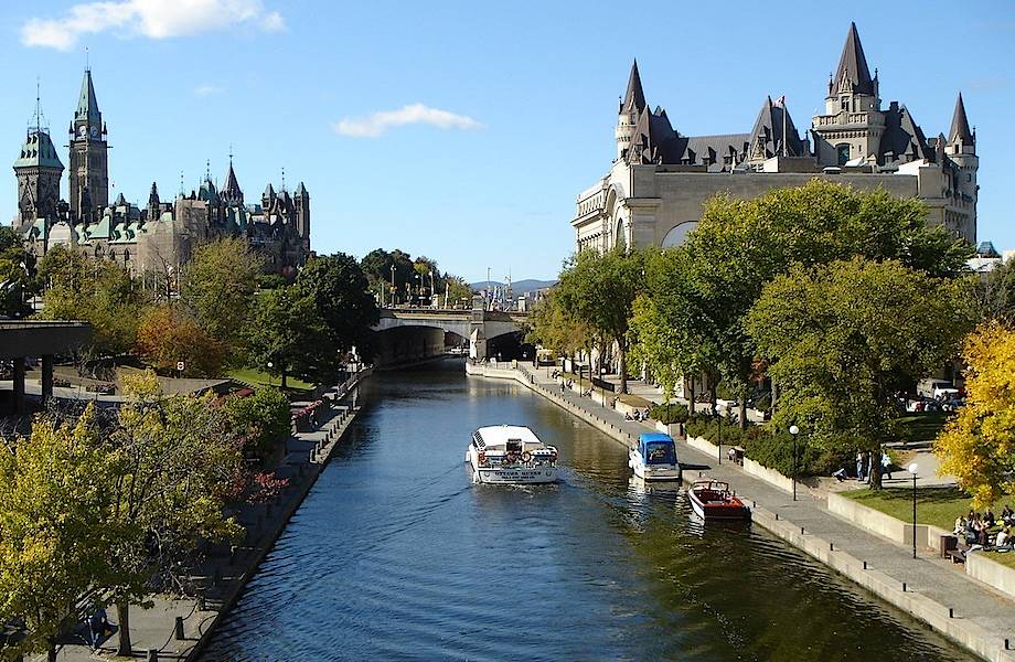
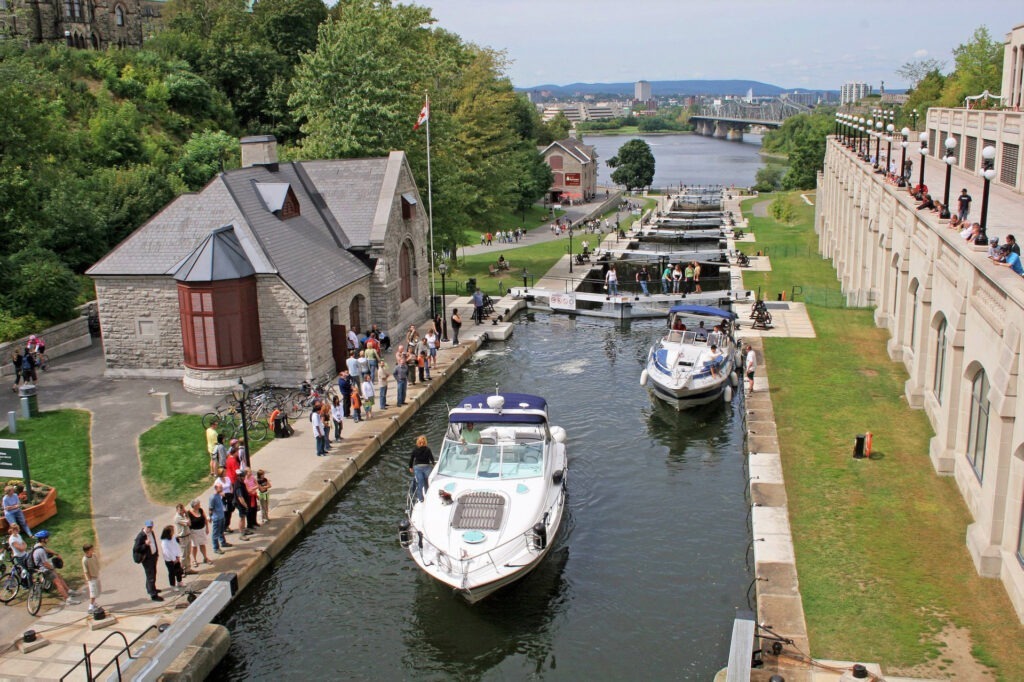
- Ottawa L ocks – eight locks in the heart of Ottawa, between Parliament Hill and Chateau Laurier, which raise ships 24 meters from the Ottawa River.
- Merrickville – here is the largest blockhouse on the Rideau Canal, built to protect the important intersection of the quality road from the St. Lawrence River with the Rideau Canal.
- Jones Falls – an impressive cascade of four locks and an arched stone dam 18 meters high and 107 meters long, which was the tallest in North America at the time of construction.
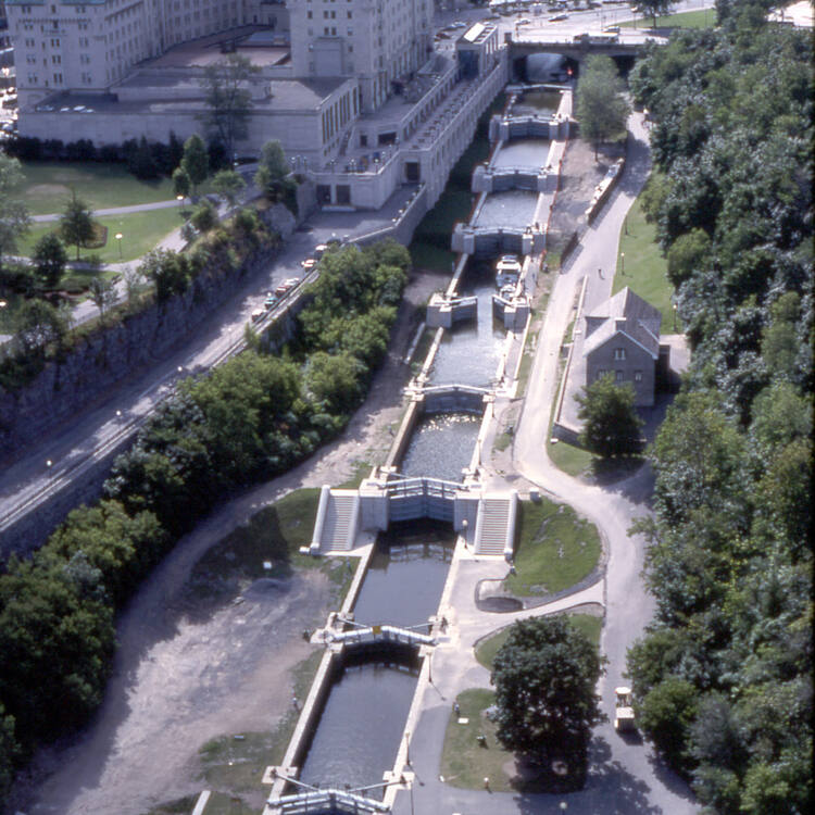
- Kingston Mills – a complex of four locks, including three locks, a turning basin and a detached upper lock, and a blockhouse.

Kingston Mills locks on the Rideau Canal. Source: Rideau-Info
Defensive structures and blockhouses
The four surviving blockhouses along the Rideau Canal are important historic landmarks:
- Kingston Mills Block house – equipped as it was during its military heyday, demonstrates how soldiers/militia lived and all the structural features of the blockhouse
- Merrickville Blockhouse – the largest on the Rideau Canal, located in a dry ditch next to the upper lock. Today it houses a museum operated by the Merrickville and District Historical Society. This blockhouse was built larger than the others because of Merrickville’s strategic location where a good road from the St. Lawrence River crossed the Rideau Canal.
- Newborough Blockhouse – although now mothballed, it remains an important historical monument to the canal’s military heritage.
- Narrows Block house – used as a lock station house, but retains all the external characteristics of a defensive structure.
In addition to the blockhouses, defensive lock keeper’s houses remain along the canal with their stone walls and loopholes clearly indicating their defensive purpose. These houses were built in response to the Upper Canada Rebellion. A key feature of these houses is their location on the ground – they overlooked both approaches to the sluice, which provided a military advantage and helped keepers see approaching ships.
Builders’ cemeteries and memorial sites
The construction of the Rideau Canal claimed the lives of about a thousand workers, mostly due to malaria and other diseases of the time. Along the route of the canal, several historic cemeteries remain where the builders are buried:
- Royal Engineersand Miners Cemetery (Newborough), the final resting place of British military engineers.
- Chaffey Cemetery and Wall of Remembrance (Chaffey Lock) – commemorating the workers who died during the construction of this section of the canal.
- McGuigan Cemetery (Merrickville) is another burial site for canal builders.
These sites serve as a reminder of the human price that had to be paid to create this engineering marvel.
Natural attractions and scenic views
The Rideau Canal route passes through the diverse landscapes of Eastern Ontario, offering numerous natural attractions:
- Hogs Back Falls – a spectacular cascade on the Rideau River in Ottawa, formed by the construction of a dam for the canal.
- Big Rideau Lake – the largest lake on the canal route and a popular destination for fishing, sailing and outdoor recreation.
- Colonel Bye’s Island – a picturesque island in Big Rideau Lake, named in honor of the canal builder.
- Lake Opinicon is one of the most scenic lakes on the route, surrounded by unspoiled nature.
The canal offers numerous wildlife viewing opportunities, including a variety of birds, beavers, otters, deer, and a host of other animals that inhabit the shoreline areas.
Communities along the Rideau Canal
Ottawa: from Baytown to the capital city
Ottawa’s history is inextricably linked to the Rideau Canal. The city was founded in 1826 as Baytown, named in honor of Lieutenant Colonel John Bye, and served as a base for the construction of the canal. The original settlement was divided into Upper Town (West) and Lower Town (East), connected by the Engineers Bridge (now the Plaza Bridge).
After the completion of the canal, Baytown continued to grow as an important transportation and trading hub. In 1855 it was renamed Ottawa, and in 1857 Queen Victoria chose it as the capital of Canada. This choice was due in part to the city’s strategic location on the Rideau Canal, which provided a safe link to Kingston and Montreal.
Today, the Rideau Canal runs through downtown Ottawa, where the locks at the foot of Parliament Hill are one of the city’s major tourist attractions. It is also home to the Bytown Museum in the former Commissariat Building, the city’s oldest stone building.
Kingston: gateway to the Great Lakes
Kingston, located at the southern terminus of the Rideau Canal, has a rich military and maritime heritage. The city was founded in 1673 as a French trading post and fort and later became an important British naval base. Kingston’s strategic location on the eastern end of Lake Ontario and at the mouth of the St. Lawrence River made it a key site during the War of 1812.
The need for a secure supply route for Kingston was one of the main reasons for the construction of the Rideau Canal. In Kingston, the canal connects to Lake Ontario through the Kingston Mills locks, which is also home to one of the four surviving blockhouses.
Today, Kingston is a thriving city with a rich historical heritage. Its port serves as a gateway to the Great Lakes and an important hub in the region’s water transportation system.
Coastal Towns: Manotick to Newborough
Along the 202-kilometer route of the Rideau Canal are many small communities, many of which owe their existence to the canal. Among them:
- Manotick – a picturesque Ottawa suburb located on the Rideau River, where historic mills and other 19th century structures remain.
- Merrickville – known as the “Jewel of the Rideau Canal” for its well-preserved Victorian architecture and large blockhouse.
- Smiths Falls – developed as an industrial center due to the power generated by the waterfalls on the Rideau River. Here the canal traverses a significant drop in elevation through a series of locks.
- Westport – a picturesque village on the north shore of Upper Rideau Lake, a popular tourist destination.
- Newborough is a small community on the isthmus between Upper Rideau Lake and Newborough Lake, home to a historic blockhouse.
These and other communities along the canal (Carrs, Burritts Rapids, Portland, Silis Bay) have retained many historic buildings and structures associated with the Rideau Canal and today attract tourists for their charm, local craft stores, restaurants, and recreational opportunities.
The Future of the Rideau Canal
Conservation and maintenance challenges
Despite its status as a World Heritage Site, the Rideau Canal faces a number of challenges in preserving and maintaining its infrastructure:
- Aging engineering structures – many of the canal’s locks, dams and other structures are nearly 200 years old and require constant monitoring and repair.
- Climatic changes – affect water levels in the canal, which can lead to flooding in the spring and water shortages in the summer. This especially affects the operation of the famous ice rink during the winter, when warmer winters make it difficult for ice to form thick enough.
- Balancing needs – the need to preserve the historic appearance of the canal while ensuring its functionality for modern use presents a challenge for governing bodies.
- Environmental concerns – include controlling invasive species, preserving water quality, and protecting ecosystems along the canal.
Parks Canada is developing and implementing long-term conservation and management plans for the canal to ensure its sustainability for future generations.
Cultural and economic significance in the 21st century
In the 21st century, the Rideau Canal retains its importance to the region’s culture and economy:
- Tourism appeal – the canal attracts millions of visitors each year who contribute significantly to the local economy.
- Cultural identity – the canal has come to symbolize engineering excellence, perseverance, and Canada’s historical development.
- Educational value – provides opportunities for students and researchers to study history, engineering, ecology and other fields.
- Quality of life – creates recreational opportunities for local residents and enhances the attractiveness of coastal communities as places to live and work.
The economic importance of the canal in the modern era lies not in freight transportation as it originally was, but in its role as a catalyst for tourism, community development and cultural heritage preservation.
International cooperation and exchange of experience
As a UNESCO World Heritage Site, the Rideau Canal is involved in international cooperation to preserve historic waterways. This includes:
- Sharing experiences with other historic canals around the world, such as the Canal du Midi in France, the Caledonian Canal in Scotland, and the Erie Canal in the United States.
- Participating in international conferences and research projects on historic canal conservation and management.
- Developing best practices to balance historic preservation with modern use of waterways.
These collaborations help find innovative approaches to common challenges and increase global recognition of the Rideau Canal as an outstanding achievement of humanity.
Conclusion
The Rideau Canal is much more than just a waterway connecting Ottawa and Kingston. It is a living testament to engineering genius, an outstanding historical monument and an integral part of Canadian heritage. Conceived as a military fortification after the War of 1812 and built under incredibly difficult conditions under the direction of Lt. Col. John Bye, the canal has surpassed its original purpose and adapted to the changing needs of society for nearly two centuries.
From commercial shipping to modern tourism and recreation, the Rideau Canal continues to play an important role in Canadian life. Its 47 locks and numerous dams, most of which are still operated by hand just as they were when they were first opened in 1832, provide an outstanding example of 19th century backwater technology.
The canal’s recognition as a UNESCO World Heritage Site in 2007 confirmed its outstanding universal value and ensured its preservation for future generations. Today, the Rideau Canal continues to inspire with its beauty, history and technical achievements, and serves as a reminder of the courage, determination and skill of those who built it.
Traveling through the historic locks and dams of the Rideau Canal, from the bustling capital city of Ottawa to historic Kingston, one cannot help but marvel at the magnitude of this achievement and its lasting impact on shaping Canada as a nation. The Rideau Canal is truly one of North America’s greatest engineering marvels – a silent witness to history that continues to tell its story today.
The locks of the Rideau Canal in Smiths Falls. Source: Visit Rideau Canal
Author Information

I’m a journalist specializing in urban issues and city politics in the Vancouver region, which I’ve covered since 1994, and I also have a strong focus on the iGaming industry. In this endlessly changing city, I cover a broad range of issues: from drug policy, bike lanes, billion-dollar development projects, homelessness, and garbage debates, to the rapidly evolving world of online gaming, including regulatory landscapes, technological advancements, and market trends. I write frequently for the Globe and Mail’s B.C. section and Report on Business. From 2008 to 2015, I had a regular column in Vancouver magazine, “Urban Fix,” which apparently resonated with readers so much that it earned me a few regional and national awards.